


硕士生导师
个人信息Personal Information
办公地点:犀浦校区X4537
主要任职:测绘遥感信息系副教授/硕士生导师
其他任职:中国测绘学会工程测量分会委员(2021-2026)/矿山与地下测量专委会委员(2018-2021,2022-2027)
所在单位:地球科学与工程学院
 报考该导师研究生的方式
欢迎你报考张同刚老师的研究生,报考有以下方式:
1、参加西南交通大学暑期夏令营活动,提交导师意向时,选择张同刚老师,你的所有申请信息将发送给张同刚老师,老师看到后将和你取得联系,点击此处参加夏令营活动
2、如果你能获得所在学校的推免生资格,欢迎通过推免方式申请张同刚老师研究生,可以通过系统的推免生预报名系统提交申请,并选择意向导师为张同刚老师,老师看到信息后将和你取得联系,点击此处推免生预报名
3、参加全国硕士研究生统一招生考试报考张同刚老师招收的专业和方向,进入复试后提交导师意向时选择张同刚老师。
4、如果你有兴趣攻读张同刚老师博士研究生,可以通过申请考核或者统一招考等方式报考该导师博士研究生。
-
[2025]
章露,张同刚*,马文静, 冯云飞,陈艺文,基于统一参数点云配准的钢轨磨损分析方法
江来伟,赵玉元,岑敏仪,等. 运营高速铁路竖曲线动态检测高低S形长波不平顺分析 [J]. 中南大学学报(自然科学版), 2025, 56 (07): 3064-3074.
李阳腾龙,王平,岑敏仪,等. 无砟轨道高平顺多约束自适应迭代优化方法研究 [J]. 铁道学报, 2025, 47 (03): 91-98.
李文君,张同刚,蒋红彪,等.一种城区机载和车载点云的快速配准算法[J].测绘与空间地理信息,2025,48(01):205-208.
易炼,殷晓广,张同刚.基于螺栓孔特征的盾构隧道管片接缝识别[J].铁道标准设计,2025,69(02):111-118.DOI:10.13238/j.issn.1004-2954.202407180003.
[2024]
陈婷婷,冉孟辉,张同刚,等.基于MLS的新建线路补砟量检测方法[J].测绘与空间地理信息,2024,47(12):171-174+177.
陈淋,张同刚,王鑫,等.基于线对间法向距离特征的机载和车载点云配准算法[J].测绘与空间地理信息,2024,47(12):167-170.
蒋红彪,炊宇恒,张同刚,等.基于线特征的大规模城市场景点云配准算法[J].测绘与空间地理信息,2024,47(12):178-181.
陈婷婷,张同刚,李文君,等.面向CRTSⅢ轨道板测量的点云快速拼接算法[J].测绘与空间地理信息,2024,47(10):178-181+184.
殷晓广,张同刚,马文静,等.基于车载扫描点云的地铁盾构隧道椭圆度分析[J].铁道勘察,2024,50(04):59-66.DOI:10.19630/j.cnki.tdkc.202401080003.
贾仕强,张同刚,陈婷婷,等.稳健的CRTSⅢ轨道板关键面提取算法[J].测绘地理信息,2024,49(01):96-103.DOI:10.14188/j.2095-6045.2022057.
[2023]
卜志雄, 岑敏仪, 阮文斌, 江来伟, 周磊, 张同刚, 刘宗鑫, 张欢, 张宝美, 刘星辰.城市轨道交通工程的轨道控制网网形与测量数据处理研究[J].测绘与空间地理信息,2023,46(09):71-75.
江来伟,岑敏仪,张同刚,等.32 m简支梁桥有砟轨道精捣上拱误差模型及其修正研究[J].铁道学报,2023,45(08):129-137.
岑敏仪, 卜志雄, 李阳腾龙, 阮文斌, 张同刚, 周磊, 江来伟, 刘宗鑫, 高颖, 王翰.地铁运营线无砟轨道消除抖动晃车的精测精调技术[J].测绘与空间地理信息,2023,46(07):4-7+11.
陈丞,张同刚,李涛,等.面向轨道维护的可变轨距轨道模型与钢轨点云的配准方法[J].铁道学报,2023,45(01):91-97.
张宝美,岑敏仪,张同刚,等.高速铁路动检车检测数据里程偏差修正算法研究[J].铁道标准设计,2023,67(08):64-69.
[2022]
安炯,张同刚*,沈迅,贾海龙,邓川,邢庭松,金国清(2022)基于Lidar点云的铁路隧道横断面提取. 测绘与空间地理信息45(1)100-103
邢庭松,彭金涛,张同刚.基于车载激光扫描点云的铁路隧道横断面提取[J].技术与市场,2022,29(06):7-10.
李涛,谢富贵,张同刚,等.多投影带下线路平面坐标正反算模型[J].测绘与空间地理信息,2022,45(11):222-225+229.
[2021]
安炯,张同刚*,贾海龙,邓川,邢庭松.(2021) 适应任意形状铁路隧道Lidar点云的断面差异分析方法. 测绘与空间地理信息.44(4)180-184
李涛,谢富贵,张同刚*,钟丹,阚余辉,贾世强. (2021)多投影带下线路平面坐标正反算模型 [J].测绘与空间地理信息(录用)
[2020]
Fugui XIE, Tonggang ZHANG* , Dan ZHONG, Yuhui KAN, An automatic spherical targets detection method with multiple geometrical constraints, ISMR2020.The 7th International Symposium on Innovation & Sustainability of Modern Railway. (EI:20210109712107)
Dan ZHONG, Tonggang ZHANG* , Yuhui KAN, Fugui XIE, The fast and continuous railway clearance inspection algorithm based on vehicle LiDAR point cloud, ISMR2020.The 7th International Symposium on Innovation & Sustainability of Modern Railway. (EI:20210109712108)
Yuhui KAN, Tonggang ZHANG*, Dan ZHONG, Shiqiang JIA, Fugui XIE ,Building contour extraction from Airborne LIDAR point cloud for Digital Line Graphic, SPIE Proceedings 11525, SPIE Future Sensing Technologies (FST2020), 115250O (8 November 2020); doi: 10.1117/12.2580325 [Oral][EI:20204909589442]
Cheng CHEN, Tonggang ZHANG*, Yuhui KAN, Shichao LI, Guoqing JIN, A rail extraction algorithm based on the generalized neighborhood height difference from mobile laser scanning data. Proceedings of SPIE 11525, SPIE Future Sensing Technologies (FST2020), 115250N (8 November 2020); doi: 10.1117/12.2580371[Oral] (EI:20204909589441)
Tonggang ZHANG*, Yuhui KAN, Hailong JIA, Chuan DENG, Tingsong XING.(2020)Urban Vehicle Extraction from Aerial Laser Scanning Point Cloud Data. International Journal of Remote Sensing, 2020, 41(17), 6664–6697 [SCI:ME1NV/EI:20202808908225]
Maolin FENG, Tonggang ZHANG*, Shichao LI, Guoqing JIN, Yanjun XIA,(2020)Improved minimum bounding rectangle algorithm for regularized building boundary extraction from aerial LiDAR point cloud with partial occlusion,International Journal of Remote Sensing, 41(1), 200-219 Full text[SCI:JD3TL/EI:20193207278420]
[2019]
Xuece MIAO, Laibo YU, Huijuan ZHANG, Chunjiang GUO, Hui YANG, Zhifang LIU, Fenhong TANG, Tonggang ZHANG*, (2019)Railway Slope Extraction Using Mobile Laser Scanning Point Cloud,Joint EOEC-GIT4NDM conference (The 6th International Conference on Earth Observation for Environmental Changes (EOEC 2019) &the 8th International Conference on Geo-information Technologies for Natural Disaster Management),24-26, Jun, Chengdu, China
[2018]
雷志秋; 张同刚; 刘晓华; 李春华; 胡琦佳; 黄丁发 (2018) 盾构隧道点云典型要素分割. 测绘科学技术学报.35(4):395-399
Shichao LI, Tonggang ZHANG*, Cheng CHEN, Jiong AN. (2018). Precision Assessment of High-speed Railway slab intelligent inspection system. [Invited Oral presentation], International Symposium on Precision Engineering Measurements and Instrument(ISPEMI), Proceedings of SPIE 110530F, August 8-10, 2018, Kunming, China [EI:20191106638809/ISTP:BM2RE]
Li, Yangtenglong, Minyi Cen, Tonggang Zhang. (2018). A novel data processing method for sectional rail measurements to detect track irregularities in high-speed railways, Proceedings of the Institution of Mechanical Engineers, Part F: Journal of Rail and Rapid Transit, 232(2): 435-444. [SCI]
Chen, Xiaowei, Minyi Cen, Haitao Guo, Tonggang Zhang, Chuan Zhao, Baoming Zhang. (2018). Chinese satellite photogrammetry without ground control points based on a public DEM using an efficient and robust DEM matching method, International Journal of Remote Sensing, 39(3): 704-726. [SCI FV7QQ]
[2017]
张同刚, 王昆仑, 金国清. (2017). 基于高斯牛顿法的 DEM 匹配算法, 西南交通大学学报, 52(3): 584-592. [EI]
施洲, 蒲黔辉, 张同刚, 岳青. (2017). 大型公铁两用斜拉桥健康监测数据的时域峰值统计及频域融合处理, 中国铁道科学, 38(2): 55-64. [EI]
耿中利, 张同刚*, 杨怀志, 杨书生, 施洲. (2017). 大跨钢桁梁形变对轨道平顺性的影响, 测绘科学, 42(8): 142-145.
陈小卫, 岑敏仪, 卢俊, 张同刚, 张保明. (2017). 一种改进的快速最小高差 DEM 匹配方法, 测绘科学技术学报, 34(4): 399-405.
Zhang, T., G. Vosselman, S. J. Oude Elberink. (2017). Vehicle recognition in aerial Lidar point cloud based on dynamic time warping, ISPRS Annals of Photogrammetry, Remote Sensing and Spatial Information Sciences, IV-2/W4: 193-198.[EI:20190406428787] doi:10.5194/isprs-annals-IV-2-W4-193-2017
Chen, Xiaowei, Baoming Zhang, Minyi Cen, Haitao Guo, Tonggang Zhang, Chuan Zhao. (2017). SRTM DEM-aided mapping satellite-1 image geopositioning without ground control points, IEEE Geoscience and Remote Sensing Letters, 14(11): 2137-2141. [SCI]
[2016]
张同刚, 岑敏仪, 任自珍. (2016). M-LZD 算法中表面变形的可探测性分析, 测绘通报(6): 10-13.
陈小卫, 陈小卫, 张保明, 张同刚, 郭海涛, 岑敏仪. (2016). 公开 DEM 辅助无地面控制点国产卫星影像定位方法, 测绘学报, 45(11): 1361-1370. [EI]
[2015]
苏林全, 张同刚*. (2015). 运营期高速铁路沉降监测断高处理方法, 测绘科学, 40(S1): 34-36.
冯义从, 岑敏仪, 张同刚. (2015). 地形自适应车载 Lidar 点云滤波, 测绘科学, 40(10): 138-141.
Zhang, Tonggang, Minyi Cen, Zizhen Ren. (2015). A novel method for improved DEM deformation detection, European Journal of Remote Sensing, 48(1): 71-84. [SCI/EI]
Wang, Kunlun, Tonggang Zhang. (2015). Gauss-newton method for DEM co-registration, International Conference on Intelligent Earth Observing and Applications(IEOA), Proceedings of SPIE 9808, Guilin, China, 98080M. [EI]
[2014]
冯义从, 岑敏仪, 杨晓芸, 张同刚. (2014). 基于 3D 格网与哈希表的车载 LiDAR 点云八叉树索引, 测绘科学, 39(6): 104-107.
[2013]
Feng, YiCong, MinYi Cen, TongGang Zhang. (2013). An algorithm of fast index constructing and neighbor searching for 3D LiDAR data, Intelligent Information, Control, and Communication Technology for Agricultural Engineering (PIAGENG),Proceedings of SPIE 8762, 27-28 Jan, Sanya, China, 8762, 87620Y. [EI]
[2011]
杨容浩, 岑敏仪, 张同刚, 杨佳. (2011). 融合遗传算法的最小二乘无控制 DEM 匹配, 测绘科学, 36(1): 146-150.
岑敏仪, 张同刚, 李劲, 谭俊. (2011). CPIII 控制网测量数据处理方法的比较, 铁道学报, 33(8): 99-102. [EI]
Zhang, T., Z. Hu, C. Yang, Y. Liu. (2011). Hybrid prediction model for high-speed railway embankment settlement using grey artificial neural network, 1st International Workshop on High-Speed and Intercity Railways (IWHIR), Lecture Notes in Electrical Engineering 148, 19-22 Jul, Shenzhen, Hongkong, China, 2, 179-186. [EI]
[2010]
Zhang, T., M. Cen, Z. Ren, R. Yang, Y. Feng, J. Zhu. (2010). Ability to detect and locate gross errors on DEM matching algorithm, International Journal of Digital Earth, 3(1): 72-82. [SCI]
Liu, Guoxiang, Hongguo Jia, Rui Zhang, Minyi Cen, Tonggang Zhang. (2010). Subsidence detection by psinsar based on high resolution terrasar-x images, Progress in Electromagnetics Research Symposium, 22-26, Mar, Xi'an, China, 11-15. [EI]
[2009]
张同刚*,岑敏仪,冯义从,杨容浩,任自珍,(2009).采用截尾最小二乘估计的DEM匹配方法. 测绘学报,38(2),144-151 [EI 20092012082467 ]
Zhang Tonggang, et al (2009), Multi-temporal DEM co-registering for detecting terrain changes using local invariant patches, (Proceedings of SPIE 7471) SPIE proceedings of the 2nd International Conference on Earth Observations for Global Changes, 125-131 ( EI )
张同刚, 等(2009), LZD模型多维粗差发现和定位能力分析, 测绘科学, 34(4), 144-146
任自珍,岑敏仪,张同刚等(2009),基于等高线表面估计滤波方法,遥感学报,13(1), 21-23
任自珍,岑敏仪,张同刚等(2009),基于等高线形状分析法的LIDAR建筑物提取,西南交通大学学报.自然科学版, 44(1), 83-86 ( EI 20090811917442 )
任自珍,岑敏仪,张同刚等(2009),基于等高线表面估计法的LIDAR数据DEM提取,测绘科学,33(6), 21-23
郑莹, 岑敏仪, 张同刚(2009), 铁路轨道的数码影像纠正,测绘, 2009(1) , 15-18
[2008]
Zhang Tonggang, et al (2008), Robust DEM co-registration method for terrain changes assessment using least trimmed squares estimator, Advances in Space Research, 41, 1827-1835. ( SCI:314ZG , EI 20081911241162)
Zhang Tonggang, et al. (2008) Efficient correspondence criterion for gridded DEM co-registration. International Archives of the Photogrammetry, remote sensing and Spatial Information Sciences. 37(4), 1241-1246.
Qin Jun, Hu Cheng, Zhang Tonggang, et al (2008) Multi-temporal DEM matching method without control points in debris-flow area. International Archives of the Photogrammetry, remote sensing and Spatial Information Sciences. 37(8), 1235-1237.
Ren Zizhen, Zhou Guoqing, Cen Minyi, Zhang Tonggang , et al (2008) A Novel method for extracting building from LIDAR data –Fc-s method. International Archives of the Photogrammetry, remote sensing and Spatial Information Sciences. 37(1), 283-289.
[2007]
冯义从, 岑敏仪, 张同刚(2007). 无控制DEM匹配与差异探测应用于泥石流灾害监测. 水土保持通报, 27(1),74-77
[2006]
张同刚, 岑敏仪等(2006). 基于差分模型的无控制DEM差异探测方法. 西南交通大学学报.自然科学版, 41(1). 91-96. (EI检索号:06139783845)
Zhang Tonggang, Cen Minyi, Zhou Guoqing, et al(2006). A new method for debris-flow detection using multi-temporal DEMs without ground control points. International Journal of Remote Sensing, 27(21).4911-4921 (SCI检索号:120KX, EI检索号:064910290266)
张同刚, 岑敏仪等(2006). 无控制DEM匹配的最小法向距离算法. 自然科学进展, 16(7). 868-873.
张同刚, 岑敏仪等(2006). 用于无控制DEM匹配LZD和ICP算法的比较. 中国图象图形学报, 11(5). 714-719.
张同刚, 岑敏仪等(2006). 无控制DEM表面差异探测研究. 测绘科学, 31(3). 36-38.
张同刚, 岑敏仪等(2006). 多时相DEM匹配探测泥石流地表变形的新方法. 水土保持通报, 26(3). 96-99.
吴兴华, 姚令侃, 张同刚(2006). 基于GIS的滑坡体积特征分析. 灾害学, 21(3). 22-26
Zhang Tonggang, Cen Minyi, Zhou Guoqing, et al(2006). Automatic detection of terrain deformation in mudslide areas using DEM and remote sensing imagery. 3rd International Symposium on Future Intelligent Earth Observing Satellites (FIEOS'06). Beijing, China.
Zhang Tonggang, Cen Minyi, Zhou Guoqing, et al(2006). Lidar-derived DEM data self-verification for natural disaster analysis. 3rd International Symposium on Future Intelligent Earth Observing Satellites (FIEOS'06). Beijing, China
[2005]
Zhang Tonggang, Cen Minyi, Zhou Guoqing, et al(2005). Fully automatic DEM deformation detection without control points using differential model based on LZD algorithm. 25th IEEE International Geoscience and Remote Sensing Symposium. Seoul, Korea,3982-3985.(EI检索号: 06289994317, ISTP检索号:BEG75)
张同刚, 岑敏仪等(2005). 地形起伏对GPS工程控制网高程异常的影响. 铁道学报, 27(1). 79-83. (EI检索号:05108870933)
冯义从, 岑敏仪, 张同刚(2005). 无控制DEM匹配优化技术. 计算机工程与应用 41(23). 32-34.
[2004]
张同刚, 岑敏仪等(2004). LZD 算法改进及其在泥石流探测中的应用. 两岸四地地理信息系统发展研讨会论文集. 香港. 2004.
张同刚, 岑敏仪等(2004). 基于多时相航片探测泥石流地区地表变化. 第一届数字近景摄影测量学术研讨会论文集. 湖北武汉 武汉大学
-
完整论文列表 成果应用 Baidu学术 ResearchGate SPIE Proceedings
面向轨道维护的可变轨距轨道模型与钢轨点云的配准方法
Registration Algorithm of Variable Gauge Track Model and Rail Point Cloud for Track Maintenance陈丞, 张同刚, 李涛, 沈迅, 邓川, 金国清
铁道学报 2021 录用
Full Paper:
基于车载Lidar技术相关的硬件和算法的快速发展,具备发展成快速车载轨道测量技术手段的潜力,从而替代传统的地面人工轨道测量手段。本文针对其中根据钢轨点云获取轨道轨距、钢轨位置等参数的问题,定义了可变轨距轨道模型(VGT, Variable Gauge Track Model),并在此实现了可变轨距轨道模型与钢轨点云的配准方法。新算法在配准迭代过程根据钢轨点云到轨道工作边的距离来动态调整模型轨距,从而在轨道配准精度和轨距测量精度两项关键指标获得了同步提高。通过模拟数分析了存在不同轨距偏差、超高等情况下算法性能,并和单钢轨轨道模型和固定轨距轨道模型的配准结果进行了比较。最后通过一段干线铁路的实测点云进行测试,试验结果表明单钢轨轨道模型配准后左右钢轨的平行性得不到保证;在直线段与固定轨距轨道模型配准精度和轨距测量精度基本相当,配准精度为0.16mm;在曲线段可变轨距轨道模型配准精度和轨距测量精度不受轨距变化的影响,显著优于固定轨距轨道模型的结果。
Building contour extraction from Airborne Lidar point cloud for Digital Line Graphic
Yuhui KAN, Tonggang ZHANG*, Dan ZHONG, Shiqiang JIA, Fugui XIE
Proceedings of SPIE 11525, SPIE Future Sensing Technologies, 115250O (8 November 2020)
Full Paper: SPIE ResearchGate
Based on IMBR algorithm, this paper proposes an algorithm for building contour extraction which is suitable for different scale digital line graphic (DLG). The new algorithm solves the tooth contour that may occur when IMBR algorithm is used to extract building contour. Firstly, a plane extraction algorithm based on region growth is used to extract the point cloud of the building roof. The algorithm introduces graded seed points and neighborhood-constrained growth criteria to avoid dividing the tree point cloud into building planes. Then, a Foot Point Correction algorithm is proposed to avoid the tooth contour in IMBR algorithm. The experimental results show that the Correctness and completeness of extracting building roof point cloud are above 97%. There is no tooth contour in the extracted building contour, which can meet the requirements of generating DLG with different scales.
A rail extraction algorithm based on the generalized neighborhood height difference from mobile laser scanning data
Cheng CHEN, Tonggang ZHANG*,Yuhui KAN, Shichao LI, Guoqing JIN
Proceedings of SPIE 11525, SPIE Future Sensing Technologies, 115250N (8 November 2020)Full Paper: SPIE ResearchGate
Accurate and complete rail extraction from mobile laser scanning (MLS) data is currently a fundamental and challenging problem for its application on the railway. By using the track knowledge, a signed cylindrical neighborhood difference is defined as the rail descriptor and then proposed a new rail extraction algorithm from MLS data. It can extract accurate, continuous, and complete railhead, which is most critical for the rail geometric parameter and centerline, of the entire railway. Moreover, it can successfully extract the railhead of the main-line, including the curve section with different superelevation, and turnout. A 3-km long trunk railway, including main-line and turnout, straight line and curve line, located in the southwest of China is selected to test the performance of the proposed rail extraction algorithm. The experimental results show that the proposed algorithm can correctly extract the railhead of the whole railway, with an overall accuracy (F-measure) of 88.73%. Its accuracy is improved by 42.68% compared with the rail extraction algorithm based on spherical neighborhood difference.
Urban Vehicle Extraction from Aerial Laser Scanning Point Cloud Data
Tonggang ZHANG*, Yuhui KAN, Hailong JIA, Chuan DENG, Tingsong XING
International Journal of Remote Sensing, 2020, 41(17), 6664–6697Full Paper: IJRS ResearchGate
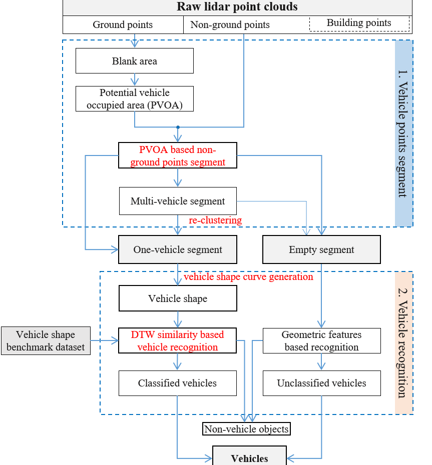
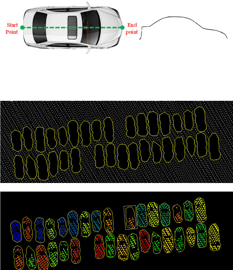
A vehicle extraction method is proposed in this paper to extract vehicles in urban areas more accurately from airborne point clouds. First, the ground points are separated from the non-ground points, and a potential vehicle-occupied area (PVOA) is then extracted from the ground point cloud. A PVOA-based non-ground point cloud segmentation method is proposed in this work, and a gap-based method is put forward to re-cluster the segment, which may include multiple vehicles. The non-ground point cloud is clustered into a series of one-vehicle segments and empty segments. Following this, a shape-based vehicle recognition method is presented that can judge whether or not a given segment is a vehicle using a dynamic time warping similarity measurement. In addition to judging whether or not a segment is a vehicle, the category of each vehicle can also be determined...
An improved minimum bounding rectangle algorithm for regularized building boundary extraction from aerial LiDAR point clouds with partial occlusions
Maolin FENG, Tonggang ZHANG(*), Shichao LI, Guoqing JIN, Yanjun XIA
International Journal of Remote Sensing, 2020, 41(1), 200-219Full Paper: ResearchGate IJRS
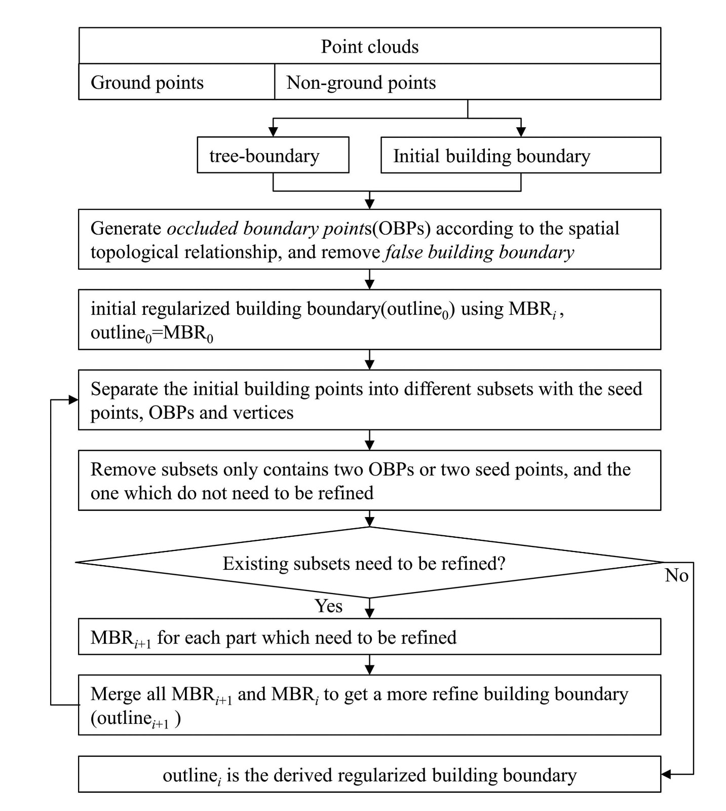
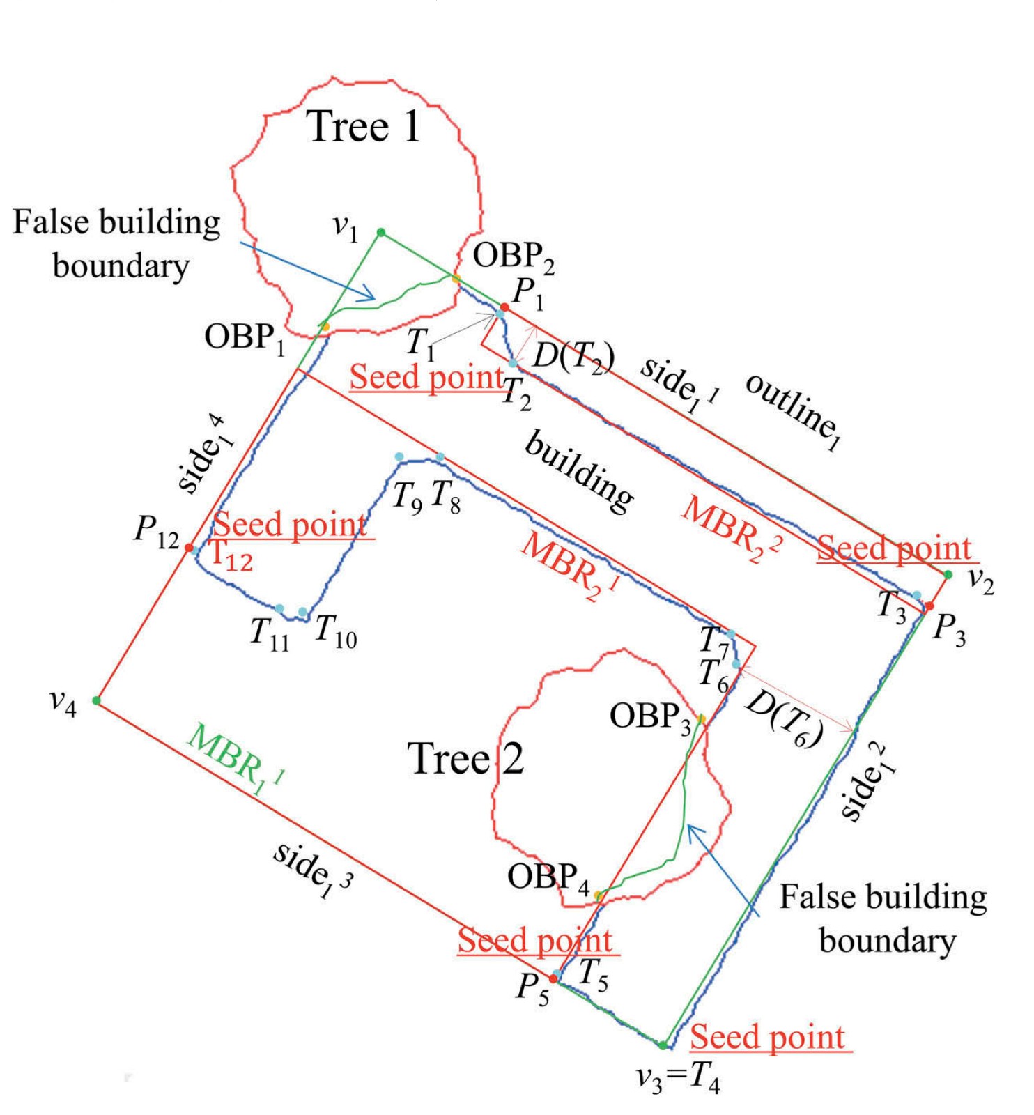
In this paper, we propose an improved minimum bounding rectangle (IMBR) algorithm to extract complete and accurate regularized building boundaries with and without partial occlusion from aerial LiDAR point clouds. The new algorithm only uses LiDAR point cloud and doesn't need any additional data source. In addition, the algorithm can be applied to buildings with complex shapes....
-
行业规范
《客运专线无碴轨道铁路工程测量暂行规定》 (铁建设[2006]189 号)
《高速铁路工程测量规范》 (TB10601-2009)
《铁路工程沉降变形观测与评估技术规程》 (Q/CR9230-2016)
专利
CN2025101768878,【发明专利】谭俊,张同刚,等一种桥梁墩顶精确建模的地面控制方法,申请日: 2025年02月18日
CN2025101645539,【发明专利】谭俊,张同刚,等,一种基于高精度三维点云的桥墩架梁前复测方法, 申请日:2025年02月14日
IRES-2024-0018 [PATENT]Jun Tan, Tonggang Zhang, et al., A method for measuring the elevation of pier caps and the planar position of bolt holes on bridge piers 30 May 2024
CN202211165325.6【发明专利】岑敏仪; 张同刚; 谭俊; 张宝美; 刘星辰,多通道轨检数据自适应里程修正及评价方法,申请日2022.09.23
CN202211540035.5【发明专利】谭俊; 张同刚; 岳绍忠; 卢勇,桥梁高墩墩顶支承垫石高程和螺栓孔平面位置测量方法 申请日2022.12.2
ZL202211360506.4 【授权发明专利】陈婷婷; 冉孟辉; 程玉培; 雷丽; 谭俊; 刘玉梅; 童湘雄; 张同刚; 炊宇恒; 熊鑫; 李文君,一种基于车载激光扫描技术的新建线路补砟量检测方法,申请日 2023/05/02 授权日:2025年08月29日
CN202110729419.0 【发明专利】邢庭松, 彭金涛, 宋智斌, 张同刚, 阚余辉 机载激光点云城市普通建筑轮廓提取方法 2021/06/30
ZL201810414013.1 【授权发明专利】张同刚,陈丞,李世超,焦镇阳 基于车载Lidar点云的铁路轨道轨距和水平参数测量方法 2018/05/03,2019/06/07
ZL201810425123.8 【授权发明专利】张同刚,李世超,张献州,陈丞,安炯 通用CRTSⅢ型无砟轨道板关键几何尺寸加工偏差快速检测方法 2018/5/7,2020/8/7
ZL201910705579.4 【授权发明专利】贾海龙,邓川,安炯,张同刚等 一种适应不同断面的隧道Lidar 点云初支面预警方法 2019/08/01
ZL201910705664.0 【授权发明专利】贾海龙,邓川,安炯,张同刚等 一种基于隧道Lidar 点云的二衬厚度数字预分析方法 2019/08/01
ZL201910446630.4 【授权发明专利】张同刚,陈丞,李世超,安炯,阚余辉,谢富贵,一种基于广义邻域高差的车载Lidar钢轨点云提取方法 2019/5/27 2022/09/16
ZL201510759672.5【授权发明专利】施洲; 蒲黔辉; 张贵忠; 闫志刚; 赵钰; 岳青; 吴来义; 张同刚,基于健康监测数据的高铁大型桥梁性能评定方法2016.01.13,2019.04.23
[国家专利局]
软件著作权
2013SR104267 分布式高速铁路沉降监测数据管理系统(V1.0)
-
系统APP下载,请用手机浏览器扫描二维码下载。
